Introduction
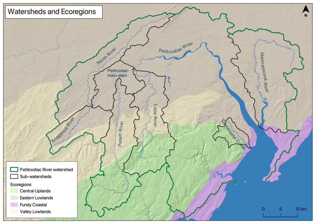
This Pollett River Stewardship Plan is one of a series of seven such documents compiling, detailing, and presenting information about tributaries of the Petitcodiac River and surrounding watersheds. The purpose of this series of documents is to enable prioritization and planning of restoration activities within the following watersheds: 1) Demoiselle Creek, a small watershed that drains directly into Shepody Bay, near the mouth of the Petitcodiac River estuary, 2) the Memramcook River, immediately adjacent to the mouth of the Petitcodiac River at Fort Folly Point, 3) the main-stem of the Petitcodiac extending between the Village of Petitcodiac (where the Petiticodiac “begins”) down to the head-of-tide at Salisbury, and four tributaries of the Petitcodiac River system, 4) Little River, 5) Pollett River, 6) Anagance River, and 7) the North River. The location of these watersheds in or near the Petitcodiac system, (just outside of Moncton New Brunswick) is presented in Figure 1.
Each watershed was assessed according to the four-level approach laid out in the Department of Fisheries and Oceans document, “Ecological Restoration of Degraded Aquatic Habitats: A Watershed Approach” (Melanson et. al 2006). Under this process the first level of assessment is an examination of the land use history of the watershed. The second level of assessment looks at the current impacts. The third level of assessment considers the aquatic and riparian habitat, and the fourth level of assessment then brings this information together to develop an aquatic habitat rehabilitation plan that identifies priorities and opportunities for interventions within each watershed to advance the goal of habitat restoration.
This stewardship plan claims no authority by which to drive its implementation. Instead, it is intended simply to serve as a publicly available resource to organize available information and help inform future decision making by identifying, and prioritizing needs and sites for activities to enhance habitat quality and promote species recovery. It is intended to serve as a reference, not to be read line by line. It is current and definitive to the time of writing, but constantly evolving and will never assume an absolute “final” form. Instead, will be updated and superseded as additional information becomes available.
Demoiselle Creek
Memramcook River
Pollett River Stewardship Plan Contents
Introduction
Pollett River
First Level Assessment – Land Use History of the watershed
– Forestry Practices
– Agricultural Practices
– Mining & Other Practices
– “Indian Affairs”
Second Level Assessment- Current Impacts
– Forestry Practices
– Agricultural Practices
– Transportation Development
– Herbicide and Pesticide Use
– Mining Practices
– Fort Folly First Nation
– Urban Development
Third Level Assessment – Aquatic and Riparian Habitat Assessment
– Wildlife
– Water Quality
– Rapid Geomorphic Assessment (RGA)
Fourth Level Assessment – Aquatic Habitat Rehabilitation Plan
– Summary of Issues Identified from Information on Current Impacts
– Summary of Issues Identified from Aquatic and Riparian Habitat Assessment
– Restoration Activities Undertaken
– Opportunities for Future Restoration Activities
References
Appendix: SAR Species Checklists for Restoration Projects


