First Level Assessment- Land use History of the Pollett River Watershed
Historical Mining & Other Activities
“Indian Affairs”
“Indian Affairs“
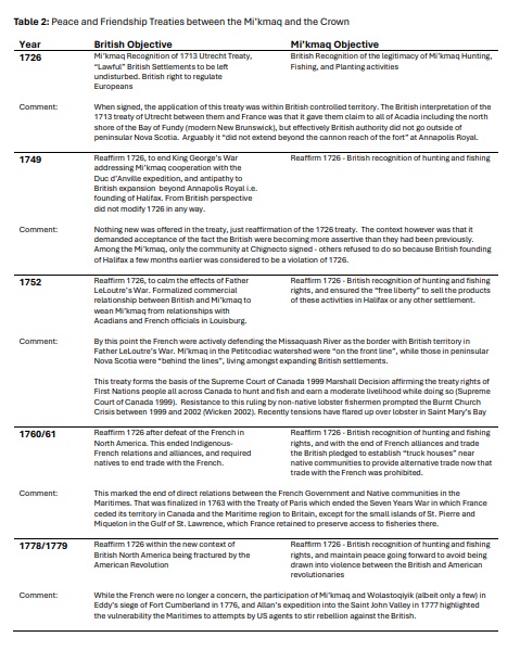
As laid out in previous sections, the Mi’kmaq and the Crown entered into a series of Peace and Friendship treaties between 1726, and 1779 (Nova Scotia Archives 2020), which form the basis of treaty rights held by the Mi’kmaq today. These were not treaties that surrendered land, but negotiations between sovereign entities. The Mi’kmaq never surrendered title to Mi’kma’ki (Mi’gmawe’l Tplu’taqnn 2023). Treaty rights and aboriginal rights are recognized and affirmed in Section 35 of the Constitution Act 1982 (Sanderson 2017). Each treaty was briefly described in previous sections within the chronological context that gave rise to it, to track the evolution of the treaties. However, as these treaties are still in effect and still relevant in New Brunswick from that time up to today, there is also value in compiling these within a single section to provide focus, make them more easily accessible, and by doing so make them more easily understood in their entirety. The five treaties are listed and identified in Table 2. In several cases a given treaty has more than one year attached to it. That is because of the complexity of negotiations, the large number of signatory communities, and the distances between venues at a time when mobility and communications were challenging meant that in several cases the signing process for a given treaty began on one year and was not completed until the following year.
After the arrival of the Loyalists in 1783, Mi’kmaq in New Brunswick were gradually moved onto “reserves” (Walls 2010), to provide land to incoming settlers. This was made possible in part by a legal technicality. The Treaty of Paris in 1763 ended the French presence in the Maritimes, and the subsequent Royal Proclamation of 1763 recognized the property rights of the native peoples in the recently won portions of North America, but it had never been construed as applying to New Brunswick, which had been part of Nova Scotia at that time (Upton 1974). Safeguards concerning Indian lands, however questionable their ultimate value elsewhere, did not even exist in New Brunswick. Initially there had been little practical need for a policy as Mi’kmaq were few in number, and so scattered that they were not considered a threat to incoming whites. With the arrival of the Loyalists, “the Indians were driven back into the wilderness without much ceremony”. The first real expression of concern amongst the government arose during the lead up to the War of 1812 (Upton 1974) that discontent might become a problem if war with the United States created an opportunity for trouble. Despite the fact some lands had been allocated to native people, they still maintained their nomadic way of life; and the colonial government’s refusal to do anything further for them led to a complaint of “an injurious distinction between them and the Indians of Canada on one side and those within the limits of the neighboring American States on the other.” The first listing of reserved lands was not published until 1838 and it identified 15 reserves in the Province ranging from 10 up to 16,000 acres. About 60,000 total acres had been designated as Indian reserves in the early 1800s, but none were in Westmorland County (Goodrich 2020).
That changed in 1840 when the Provincial Government purchased 63 acres at Beaumont near Fort Folly Point (Goodrich 2020) at the head of Shepody Bay. The Province then conveyed this land to the Magistrates of Westmorland County in Dorchester to hold in trust as a reserve. Then 126 Mi’kmaq moved there from various places within Westmorland County that they had been living to form the Fort Folly Reserve (Perley 1841, Ganong 1899). The land was not turned over to the Mi’kmaq themselves, but vested in the county to be held for their exclusive use.


