Second Level Analysis – Current Impacts
Transportation Development
Transportation Development
A GIS layer of the road network (paved and unpaved) within the Pollett watershed was overlaid on the river and its tributaries, to yield Figure 5. In 2023 this process identified 81 crossings (52 unpaved and 29 paved) within the watershed. That was fewer than were identified with the data used in 2014 which at that time found 107 paved and 49 unpaved crossings. This is not to suggest that numbers of roads within the Pollett River watershed have declined over the intervening years, nor was such comparison the purpose of the exercise. Instead, here the goal was to provide a tool to help identify and catalogue crossings within the watershed to aid in tracking the impacts of such crossings on fish passage.
One possibility at least for the unpaved crossings is that in 2014 railway crossings and powerlines may have been lumped into the overall total. However, that doesn’t account for the lower number of paved crossings, which one would have expected to be more likely to show up in both analyses. Follow up to better understand differences in the data available is warranted. It is possible using the naked eye to note several locations in Figure 5 where both the paved and the unpaved road layers cross the water layer, yet a crossing wasn’t flagged – perhaps due to the weight assigned to the watercourse. Likewise, there are several places where crossings were identified while a road is not displayed at all- suggesting not necessarily an error but a road not prominent enough to display. These differences may account for much of discrepancy in the GIS analyses between 2014 and 2023.
Fieldwork to physically survey the actual water crossings and assess the individual impacts of these structures on fish passage has been carried out by the Petitcodiac Watershed Alliance (PWA) between 2014 and 2022 throughout the Petitcodiac watershed as part of their Broken Brooks project. Annual reports detailing that work are available for download on the publications section of their website https://www.petitcodiacwatershed.org/ , the results of which are presented in Figure 6 and summarized below.
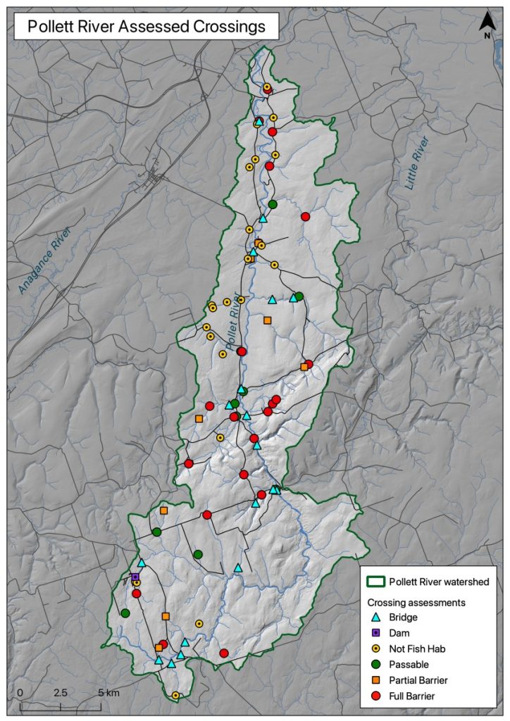
During their work the PWA located 78 crossings within the Pollett Watershed, quite comparable to the results of the 2023 GIS analysis noted above. Not surprisingly, a cursory comparison of their 78 crossings in Figure 6 lines up quite well with the 81 crossings identified during the GIS analysis presented in Figure 5. Most of the differences between the two is probably accounted for by a category of crossing that the PWA study identified as inaccessible- essentially a crossing that they had flagged to visit but were either unable to locate or gain access to.
The 78 crossings in the Pollett that the PWA successfully visited and assessed fell into five categories: Bridges (18); Dams (1); Culverts (39); Removed Culverts (1); Not Fish Habitat (19). Bridges are automatically defined as passable. Not Fish Habitat is self explanatory- a culvert located at a site fish don’t use, so passage upstream of that site is not a cause for concern. Removed Culverts are likewise not a cause for concern. Dams are not necessarily automatically barrier to passage as structures such as fish ladders and spillways can create passage- so assessment is necessary. The 39 culverts that were identified in the Pollett Watershed required individual assessment, through which the PWA determined if they were: Passable (10); a Partial Barrier to Passage (8); or a Full Barrier to Passage (21). Passable culverts were not cause for concern, though Partial and Full Barriers to Passage were identified as problems, and where possible mitigations were prescribed. Proposed methods of mitigation identified varied depending upon the nature of the barrier to fish passage. These ranged from clearing debris, to building vortex rock weirs to raise the water in plunge pools below perched culverts, to modification of flow through the culvert through installation of baffles and / or an outflow chute.
While the New Brunswick Department of Transportation and Infrastructure (DTI) is responsible for bridges and culverts on the public paved roads, they are not responsible for the vast majority of those on the unpaved roads which are likely to be on either private woodlots, industrial freehold, or crown land. If a problem culvert is identified and there is a question of who is responsible (private landowner versus DTI), GPS coordinates should allow responsibility to be confirmed through further discussions with DTI.
Rail service to Elgin from Petitcodiac was discontinued and the line was abandoned by Canadian National in 1955 (New Brunswick Railway Museum 2014). Subsequently the New Brunswick All Terrain Vehicle Federation entered into a signed agreement with the Department of Natural Resources to allow development of an ATV trail along this line.
In 1968, 28 kilometers downstream of the Pollett along the Petitcodiac, the Maritime Marshland Rehabilitation Administration (MMRA) built the Moncton to Riverview Causeway (Rudin 2021). The purpose of this structure was to protect agricultural land upstream of it from tidal flooding and storm surges while also providing a second link for vehicular traffic between the two cities. A bridge combined with less expensive upgrades to the existing system of dykes and aboiteaux could have secured these lands just as well. Either option would have satisfied the transportation needs of greater Moncton, but with different implications in terms of both short-term matters connected with financing and long-term implications for the environment (Rudin 2021). The fishway built into the causeway proved to be ineffective (Locke et al 2003). The causeway gates created a barrier to fish passage with significant consequences for native fish species in the river, which led to the decline in the populations of species such as alewife, blueback herring, rainbow smelt, and sea-run brook trout. Some species disappeared altogether from the upland reaches of the Petitcodiac (such as the Pollett), including Atlantic tomcod, American shad, and striped bass. Atlantic salmon only remained present in the river as a consequence of ongoing stocking efforts (AMEC 2005)
In April 2010 the Moncton to Riverview Causeway gates were opened as part of the Petitcodiac River Restoration Project. From 2017 to 2021 a new bridge was built to partially replace the Petitcodiac Causeway. During April of 2021 the causeway was breached and a new 160-metre-wide channel was opened up underneath it. Following the restoration of fish passage in 2010, thirteen years of monitoring movement of anadromous fish have been carried out using a fish net trap at the head of tide in Salisbury (2010 to 2022). (Redfield 2023). On October 4th, 2021 (the first year with the new channel under the bridge) the trap caught the first wild returning salmon recorded since the monitoring program began. There were 170 striped bass caught that year at the trap, nearly as many as 2018 (65 striped bass), 2019 (65 striped bass), and 2020 (43 striped bass) combined. While additional returning wild salmon weren’t caught in 2022, another 155 striped bass were – demonstrating that the 2021 result had not been a fluke. Meanwhile, numerous 40+ cm striped bass have been observed as high up in the system as a pool in the lower portion of the Pollett during snorkel surveys every year between 2018 and 2022 (except for 2021). Likewise American shad, American eels, and Atlantic tomcod have all been noted returning to the river. Of these, the latter two have shown sustained and progressive increases in numbers over the years, while invasive non-native smallmouth bass and chain pickerel have declined. Consequently, it is clear from these results that the fish community of the Petitcodiac has the capacity to recover, given the right conditions, and appears to be on its way to doing so.


