Fourth Level Assessment- Aquatic Habitat Rehabilitation Plan
Restoration Activities undertaken
Opportunities for Future Restoration Activities
Opportunities for Future Restoration Activities
Restoration Framework –Stewardship Planning, Prioritization and Engagement
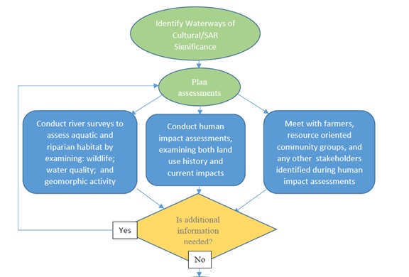
To address concerns within the watershed through an efficient use of finite resources (both human and financial), projects must be well prioritized, both in terms of the needs of the river, and those of the landowners on who’s property the project is taking place. Fort Folly Habitat Recovery has developed a series of Stewardship Plans on a watershed by watershed basis within the Petitcodiac River system, of which this Pollett River Stewardship Plan is one. These plans provide a means of tackling the challenging task of identifying local problems, determining which ones warrant immediate attention, and determining how to proceed with them once chosen. This process is laid out in Figure 38 and Figure 39.
The field work that makes up the Third Level Assessment (Aquatic and Riparian Habitat Assessment) informs decision making by providing the wide context necessary to prioritize and target project selection. Without it, decisions about which project to undertake would be made without proper appreciation of how needs at a given site compare to those at other sites elsewhere in the system. At this point there is also an opportunity to ensure that efforts are well distributed across the watershed by including consideration of where previous projects have been done, to avoid focusing too much effort in just one area within too short a time period.
Applying such information, project selection can then proceed along the flowchart presented in Figure 39, where once identified, potential projects can be ranked according to their anticipated impact and viability. Viability is determined in part by the costs and benefits of the project, but is also dependent upon landowner interest, which comes from (to the extent practical) incorporation of landowner input into planning the project so that it is consistent with the landowner’s needs.
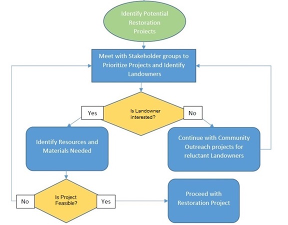
Following this two-part selection process not only aids in decision making within the organization, doing so subsequently builds the case for any individual project when pursuing resources from outside the organization to undertake it, by providing the evidence to explain to others why it is necessary. This also creates further opportunities for outreach and engagement with landowners, through accessing and participating in existing social networks. Only once a project has been determined to be both worthwhile and feasible through this process should it then proceed to the design phase. In near term- following this process the next project that has been identified to undertake (in 2025) is a failing section of bank (Figure 40) located a short distance downstream of Elgin, near Mapleton Bridge.
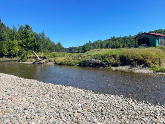
This site is higher up in the Pollett than previous projects (Figure 19), chosen precisely because that portion of the river has so far been underserved by bank stabilization efforts. It is important that such activities be well distributed through out the watershed both in terms of benefiting target species, and equitability of opportunity for landowners as well as generating public awareness. Beyond those considerations, the site warrants attention based upon its own merits given salmon redds detected there in 2020 (Figure 7) and the ranking of that reach (number 43 in Table 5) as “in adjustment” during the Rapid Geomorphic Assessments. The Primary Geomorphic process is degradation, and the secondary is aggradation, the latter of which is notable by the gravel bar in the foreground of Figure 40. Conversations with the landowner indicated significant interest on his part, as he had already had to move his house because of his failing bank. His barn (visible in Figure 40) remains near the river.
The site will be surveyed in the fall of 2024, to design a restoration plan to be implemented in the fall of 2025. That timeline is typical – required allow time to develop plans, line up funding, acquire permits and implement projects within the operational window defined by the permit (June 1st to September 30th) set to minimize negative impacts upon fish. The Province sets this work window to protect salmon by limiting such work to the summer between the point where salmon fry spawned the previous fall have emerged from their redds, and a point the next fall before adult salmon are spawning in the river (establishing the next set of redds). Beyond salmon, the presence of other threatened and endangered species in the watershed also means that such projects must be planned and implemented with awareness of these species. Fort Folly Habitat Recovery has developed project checklists (Appendix) based on species biology to provide guidelines to help avoid or minimize the risk of negative impacts.


