The Anagance River
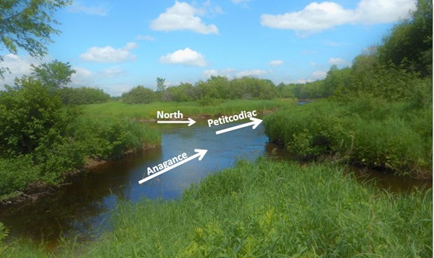
The Anagance River flows 28.4 kilometers (Pugh 1999) from its headwaters in the eastern end of Kings County down to its confluence with the North River in western Westmorland County (at the Village of Petitcodiac). The point where the two meet marks the beginning of the main stem of the Petitcodiac River (Natural Resources Canada 1997). The Anagance watershed drains 138.9 km2, making it the 4th largest tributary of the Petitcodiac. It lies mostly within the Eastern Lowlands Ecoregion, though a few points reach sufficient elevation along the ridges marking its boundaries to fall within the Valley Lowlands Ecoregion (Department of Natural Resources 2007). It is slow moving, with a sand and silt substrate (Petitcodiac Watershed Alliance 2016). Much of the river has low gradient, dropping just 25 metres along the 24.7 km between Dunsinane and its mouth (Natural Resources Canada 1997). It is narrow, convoluted and meandering, with numerous wetlands (cover: top and bottom photos). After the Anagance and the North Rivers meet, the channel (now the main stem of the Petitcodiac River) continues in an easterly direction before bending at Moncton and heading southeast into Shepody Bay.

The dominant land uses within the watershed are forestry and agriculture. Approximately 98% of the watershed is forested, broken down as follows: 42% small private woodlots, 0.5% is crown land, and 57% industrial freehold forest land owned by J.D. Irving. Only 1% of the watershed has been cleared for agriculture, 21% used to grow row crops or grains, 79% pasture or hay, and 0% blueberries (Department of Natural Resources 2014).
The lower reaches of the Anagance tend to be too warm for brook trout in the summer but are capable of accommodating salmon during their spawning run in the fall (Washburn and Gillis 1994). Historically the Anagance was considered less suitable for salmon than the North River (Huntsman 1941), let alone the Pollett or the Little which were well known as salmon rivers (Dunfield 1991). However, there are records of salmon present in the Anagance wherever suitable substrate and shelter were found (Andrews 1943; Huntsman 1944; Huntsman 1945). Elson (1961) suggested that on the Petitcodiac gaspereau (alewives and blueback herring) spawn largely in the Anagance, due to its considerable areas of still water. MacEachern (1965) specified that these were likely Alewives. Blueback herring tend spawn a short distance above the head of tide, possibly the gaspereau that Dunsfield (1991) reported spawning near the mouth of the Pollett. Alewives move further upstream than blueback herring, far into fresh water, favoring slow moving parts of rivers or still lakes for spawning (Scott and Scott 1988).
In addition to its main stem, named tributaries of the Anagance River include: Hayward Brook; Holmes Brook; and Harper Brook. While the name Anagance itself might appear obscure, it is quite descriptive, coming from Wolastoqey “Oo-ne-guncé” meaning portage (Ganong 1896). This is a reference to the transportation corridor that this valley provided historically for canoe travel between the Petitcodiac and the lower Saint John River, followed subsequently by a carriage road, the railroad, and even today’s highway system between Moncton and Saint John.


