Fourth Level Assessment – Aquatic Habitat Rehabilitation Plan
Fourth Level Assessment
Summary of Issues Identified from Current Impacts
The Broken Brooks culvert survey by the PWA (Petitcodiac Watershed Alliance 2017) visited 11 out of 69 identified water-crossings in the Anagance watershed identifying six bridges and five culverts. Among these they noted two that allowed fish passage, two culverts that were partial barriers (due to debris and excessive outflow drops) and one that is a full barrier to fish passage (Figure 7). That small sample suggests that of the 58 or so remaining water-crossings identified during the GIS analysis, there are likely quite a few that may require remedial work of some kind.
Going forward, a first step ought to be to complete the culvert survey of the watershed, to find and prioritize those crossings needing the most urgent attention. The PWA has focused their Broken Brooks project outside of the Anagance since 2017. That need is highlighted here, to try to keep it on the agenda for future work, whether PWA or FFHR.
Summary of Issues Identified by Aquatic and Riparian Habitat Assessment
Much like the lack of current or comprehensive culvert data, there is a lack of Species at Risk data from within this watershed. In both cases this is in large part because Anagance does not offer the same conservation value as the Pollett River or the Little River where salmon recovery efforts are targeted due to the importance of the spawning gravel in those tributaries. That said, the absence of data makes for a circular argument on this issue, leaving the real conservation value of this habitat harder to rank relative to other Petitcodiac tributaries.
It is reasonable to assume that Atlantic almon, American eels, or wood turtles could be present. Of the three, eels and wood turtles are both almost certainly present, while salmon are a strong enough possibility to warrant occasional monitoring – certainly prior to undertaking any intervention. Consequently, projects must be planned and implemented with awareness of the vulnerabilities of these species. Fort Folly Habitat Recovery has developed project checklists (Appendix A) based on species biology to provide guidelines to help avoid or minimize the risk of negative impacts of projects on these species.
Analysis of the RGA assessments conducted on the lower main stem of the Anagance River indicate that most of the reaches were determined to be in a transitional/stressed state while the remaining reaches were classified as in adjustment or in regime. One area in particular (reach 13) stood out as heavily impacted: RGA (Figure 11) – in adjustment, with channel widening. Reach 13 stood out as the most heavily impacted site within the Anagance watershed, but not within the Petitcodiac overall. Sites in greater need of intervention exist on both the Little River and the Pollett River. Ongoing salmon stocking efforts on both of these rivers elevate the immediate restoration priority of sites there compared to similar sites on the Anagance River. In general, the RGA results indicate that the Anagance watershed is responding to change with widening as the primary geomorphic process and degradation and aggradation as the secondary processes. Therefore, when restoration efforts are eventually undertaken, these should establish proper channel widths, ensure connection to the floodplain and promote sediment accumulation.
Reaches with excessive sediment accumulation could be restored via in-channel structures including rock vanes, upstream-V log weirs, double tree deflectors, and brush mattresses. These structures are designed to concentrate flows, promote scour pools, and narrow the channel. By narrowing the channel, the stream will regain the capacity to transport sediment as flow velocity will increase. In degrading sections of stream, rock toe structures and bank treatments can be used to establish proper channel dimensions. Structures highlighted above may also be used in degraded sections to encourage deposition in the proper areas and establish connection to the floodplain. This will encourage the channel to return to a state of dynamic equilibrium where sediment accumulation and deposition balance with flow discharge.
It is important that restoration structures be designed to fit the natural channel dimensions and hydraulic conditions of the site. Improperly placed or installed structures may do more harm than good. Logs used for structures should be freshly cut (dry logs will float, making installation difficult) and contain no rot. Recommended tree species are cedar, hemlock or spruce. If anchor stones are used for log weir/log deflector support, the rocks should be angular rather than round as round rock fits poorly and tends to roll easily. A detailed site survey including longitudinal and cross-sectional profiles, pebble counts, and riparian topography is necessary to appropriately identify a restoration strategy for a site. At the watershed scale, best management practices should be promoted to improve the stability of the Anagance River. Although pasture constitutes a low proportion of the watershed, the most degraded sections exist where agricultural is concentrated along the riparian corridor. Many of the assessed reaches of the Anagance River were identified as in adjustment and lack adequate riparian conditions due to surrounding land use. Shrub and tree planting would provide greater stability and habitat along banks that currently lack cover and will reduce sediment input. Pasture along the channel should be restricted from river access to promote vegetation growth along the riparian corridor and to improve water quality. Any opportunities to reforest the riparian corridor will lower water temperatures, reduce sediment input, minimize non-point source pollution and improve stability.
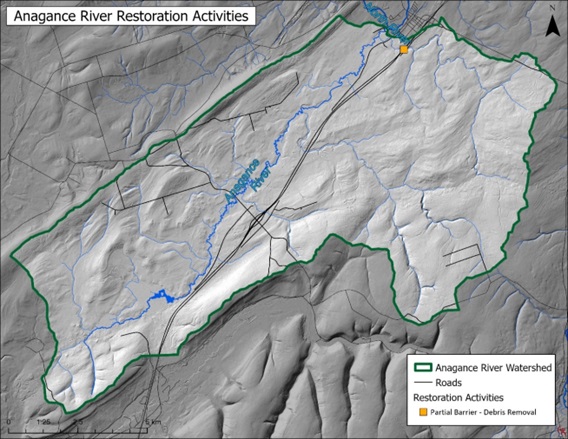
Restoration Activities Undertaken
The only restoration activity that has been done within the Anagance watershed was in 2017 when the PWA cleared debris at culvert C-147 (Figure 15) where Highway 1 crosses Holmes Brook (Petitcodiac Watershed Alliance 2017). The debris was assessed as creating a partial barrier to fish passage at that site. This work opened up approximately 10 km of upstream habitat- but this debris may well have reaccumulated over the last 7 years for the same reasons that it did previously, and so by now may once again be creating a barrier to fish passage.