The North River
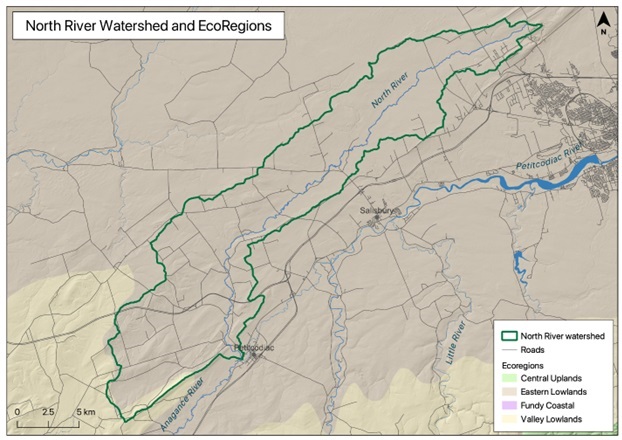
The North River flows entirely within Westmorland County, New Brunswick. Its headwaters begin north of Moncton near the bases of Lutes Mountain and Indian Mountain, from which it drains from northeast to southwest, ending where it and the Anagance River come together, near the Village of Petitcodiac, to form the main stem of the Petitcodiac River. The North River watershed covers 264.8 square kilometers, making it the third largest tributary within the Petitcodiac River system. Its drainage area lies almost exclusively in the Eastern Lowlands Ecoregion (Department of Natural Resources 2007). The river has low gradient, dropping just 80 metres along the 49 kilometers from its headwaters near Route 126 to its confluence with the Anagance (Natural Resources Canada 1997; Natural Resources Canada 2008). From the communities of Monteagle to Second North River, the river is characterized by very low flow rates, huge log jams (Home page: first photo) and grassy beaver meadows. It is a highly convoluted, meandering river with numerous oxbows and deep calm pools.
The North River is known as a trout producing river. There are no known historic salmon angling pools on the North River. In addition to its main stem, named tributaries of the North River include: Bennett Brook; Blakney Brook; Blakeney Brook; Killiam Brook; Lewis Mountain Brook; McLeod Brook; Mongomery Brook; Salt Springs Brook; and Walker Brook (Natural Resources Canada 1997; Natural Resources Canada 2008).
Unlike other tributaries of the Petitcodiac, the name of the North River appears to be rather self-explanatory. The North effectively defines almost the entire northern portion of the Petitcodiac River watershed, draining in a southwesterly direction, a short distance north roughly parallel to the main stem of the Petitcodiac (which flows in the opposite direction). The North ends where it and the Anagance meet, and the main stem of the Petitcodiac begins. From there the channel curves back upon itself, heading back in a northeasterly direction before bending again at Moncton, to head southeast into Shepody Bay.


