The Main Stem of the Petitcodiac
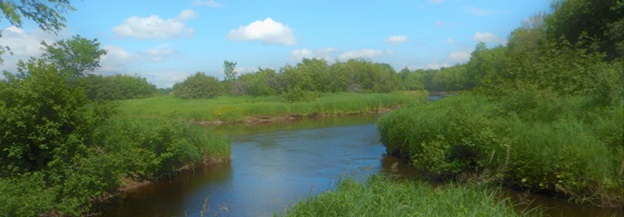
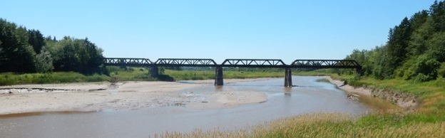
The “main stem of the Petitcodiac” refers to the 22 kilometers of river and associated watershed between the confluence of the Anagance River and the North River at the Village of Petitcodiac where the Petitcodiac River is said to “begin”(Figure 2), and the head of tide in the Village of Salisbury, where the freshwater portion of the river ends and the Petitcodiac estuary starts (Natural Resources Canada 1997). Along the way the Petitcodiac is joined by the Pollett River and the Little River, and the channel widens substantially, from 15 to 20 metres at the confluence of the Anagance and the North (Figure 3) to about 60 metres at the lowest portion of the head of tide (Figure 4). The main stem of the Petitcodiac lies entirely within the Eastern Lowlands Ecoregion (Department of Natural Resources 2007). As is typical for that ecoregion, the gradient of the river is low, falling about 20 metres over those 22 kilometres, and the water is slow moving, with an occasional cobble or bedrock dominated bottom, but mostly sand and gravel substrate. This portion of the Petitcodiac watershed drains 115.2 square kilometers, which is smaller than but somewhat
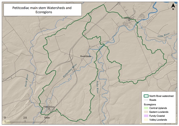
comparable in area to the various tributaries joining it. The GeoNB watershed data layer (Department of Natural Resources in 2023) defines this portion of the watershed as two segments: the O’Blenis Brook Composite and the Bannister Brook Composite, the latter of which ends at the mouth of the Little River on the river right bank and excludes the McNaughton Brook basin on the river left bank. That point is well into the head of tide, below which strong tidal influences dominate. Beyond that, the estuary continues to the east before bending at Moncton, to drain southeast into Shepody Bay, then Chignecto Bay, and on into the Bay of Fundy.
Dominant land uses within the watershed are forestry and agriculture. Approximately 81 % of the watershed is forested: 59 % private woodlots, 2.3 % crown land, and 20 % industrial freehold. 12% of the watershed has been converted to agriculture, 10.1% row crops or grains, 1.2% pasture, and 0.04% Orchards (Department of Natural Resources 2023).
In addition to the major tributaries (North, Anagance, Pollett, Little), named streams joining the Petitcodiac along the main stem include: O’Blenis Brook, Trites Brook, Nigus Brook, Chapman Brook, Hasty Brook, Bannister Brook, and French Brook.
While the name Petitcodiac might appear at first glance to be French in origin, that is an indication of the local Acadian influence. The name is actually a Francophone corruption of the Mi’kmaq name, “Petigotiag” (Knockwood 2022, personal communication) which is varyingly translated as “river that bends around back” (Rayburn 1975) , or the somewhat more poetic, “river that bends like a bow” (Petitcodiac River Heritage Committee 2000). The “bend” is often identified with “le Coude” (the elbow) the Acadian name for what is now Moncton where the river, which had been flowing east abruptly turns south to flow towards Shepody Bay. Petitcodiac was widely held to be a corruption of the French “petit coude” meaning, “little elbow” in reference to the “Bend” at Moncton “le Coude”. Ganong (1896) dispelled that notion and confirmed its Mi’kmaq origin, demonstrating that though the word was found in French documents, it never once had the form that the “petit coude” theory required, or anything like it. Instead, what alternate forms existed were consistent with Francophone adaption of the name from Mi’kmaq.
An early record (Scott 1758) of an English version of the name is Pittuiquack, from a map drafted by British Major George Scott while forcefully removing Acadian families from the upper Petitcodiac. However, Anglophones appear to have adopted the more familiar Petitcodiac quickly. By 1786, early settler of the Village of Petitcodiac David Blakeney signed as a “resident of the River Petitcodiac” on a petition for a mail road to the City of Saint John (Burrows 1984). Uncertainty as to origin of the name persisted for some time, however.
Ganong (1914a) suggests the name is more likely a description of the way the Petitcodiac bends back upon itself, as Mi’kmaq names are typically descriptive, and in the case of rivers often inform what it is like to ascend them. From the headwaters in the North River (Figure 1) near Magnetic Hill in Moncton, the main channel flows southwest to be joined by the Anagance at the Village of Petitcodiac where the government officially begins to recognize it as the Petitcodiac, at which point the river then turns to flow back northeast. By the time it reaches Moncton at “the bend” (le Coude) the river has already flowed in excess of 75 km yet is only about 14 km south of where it started, near Magnetic Hill, in Moncton.


