Third Level Assessment– Aquatic and Riparian Habitat
Primary Geomorphic Processes
The primary geomorphic process identified on the assessed reaches of the Pollett River, whether comparing individual reaches to overall number of reaches or length of the assessed channel to individual reach lengths, indicate that aggradation is the dominant process occurring. Identifying the source of the material creating the channel aggradation situation would be a priority before any instream channel or habitat restoration work was implemented. Photographs of the reaches do show some bank scour and bedload deposition in the channel, particularly below Reach 18. Reviewing historical aerial photographs indicates that the headwaters of the Pollett River has been continually under the pressure of deforestation for various wood products. Many of the cut blocks have been replanted with what appears to be softwood tees, which is typical in the province of New Brunswick. This continual commercial forestry activity in the Pollett River watershed in combination with the significant rain and freshet events of the past 12 years should certainly be considered as a contributing factor to the aggradation of the streambed and channel widening, that was identified as the two dominant geomorphic process occurring on the assessed reaches of the Pollett River.
Figure 13 shows the primary geomorphic processes in each of the 72 reaches along the Pollett. Channel aggradation was driving conditions in 43.1% percent of the reaches while widening was identified as the primary geomorphic process in 30.6% of the reaches.
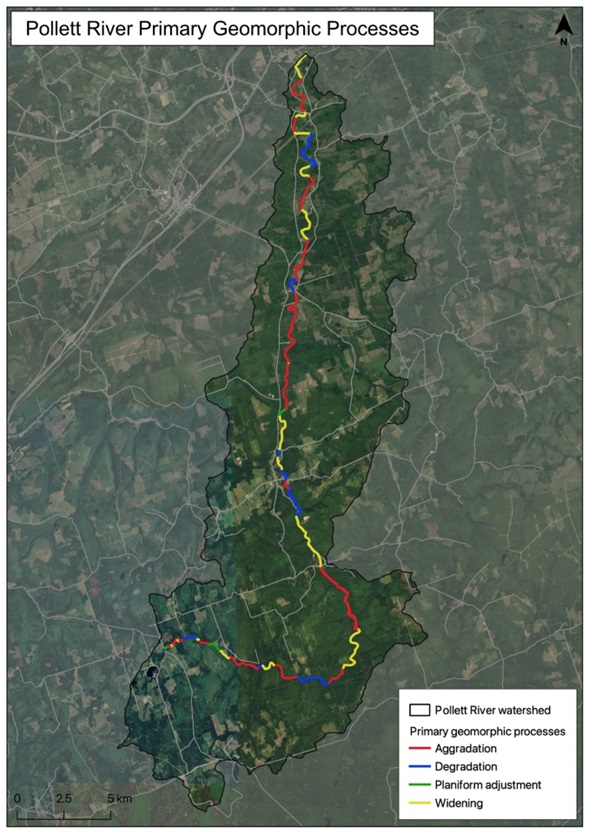
Figure 13: Pollett River Primary Geomorphic Processes
Figure 14 shows that channel aggradation was occurring in 43.1% percent of the reaches that were assesses on the Pollett River with channel widening identified in 30.6% of the reaches. When reach length is compared to overall assessed channel length, aggradation is still the dominate geomorphic process occurring followed by channel widening.
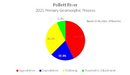
Figure 14: Pollett River Primary geomorphic processes based upon number of reaches
Based on channel length and reach length (Figure 15) aggradation is happening in 47.8% of the Pollett River channel. As almost half of the assessed channel, or approximately 28 km of the Pollett River, is in a state of channel aggradation, it is imperative that some focus on the source of this channel aggradation be identified. This could be an indication of land use practices increasing sediment load to the system, an increase in runoff during rain or freshet events, or an adjustment to the channel depth and width due to impacts from climate change.
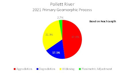
Figure 15: Pollett River Primary Geomorphic Processes based upon assessed channel length


