Third Level Assessment– Aquatic and Riparian Habitat
Secondary Geomorphic Processes
Secondary Geomorphic Processes (Figure 16) are a bit more evenly distributed. Aggradation and widening still dominate as the two secondary processes occurring, however degradation and planimetric adjustment are found more frequently here than these were among the primary processes.
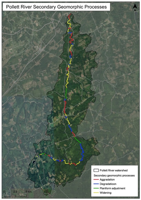
Figure 16: Pollett River Secondary Geomorphic Processes
Comparing reach length to over all assessed channel length, aggradation is still the most prevalent secondary process occurring in 33.3% of the reaches (Figure 17). Channel aggradation is closely followed by channel widening, which was identified as the secondary geomorphic process occurring in 29.2% of the assessed reaches. When looking at channel aggradation as a dominate primary and secondary geomorphic process, this equates to nearly 45 kilometres or approximately 77% of the assessed channel length of the Pollett River.

Figure 17: Pollett River Secondary Geomorphic Processes based on number of reaches
Beginning in the headwaters, the first 18 reaches of the assessed channel of Pollett River show the channel stability index fluctuate between being in a state of regime or transitional/stressed. The reaches identified as traditional/stressed in the first 18 reaches are very close to being in a state of regime. There have been some indications, based on the photographs of the reaches, that beaver activity does occur in these upper reaches of the Pollett River. However, it appears that the integrity of the constructed dams cannot withstand flooding events or the spring freshet. It should also be noted that in Reach 3 there had been some instream habitat work in the form of digger log installations. The year of installation is unknown, but the digger logs do not appear to have created adverse changes to the channel morphology. This is most likely due to the low banks, narrow channel width, and substrate size. The banks are well vegetated and significant channel flows would easily be connected to the floodplain. This would reduce any excessive scour of the channel or banks that is typically generated by digger logs.
Reaches with aggradation factor score of greater than 0.5 should be considered priority reaches for instream habitat or channel restoration activities. However, as mentioned, identifying the source of the aggradation would be the first priority so any works completed instream would not be buried by excess sediment or bedload material. Once the source of channel aggradation has been identified, any instream restoration techniques or designs would need to consider the management of the excess channel material so that it is dispersed or relocated in areas that are natural depositional locations. The installation of bank restoration techniques or instream structures will also need to be designed around attaining the channel back to a more natural width. The correct channel width should be calculated for each reach to ensure that the channel width is able to accommodate the flows based on the hydraulic flow conditions of that reach.


