Fourth Level Assessment – Aquatic Habitat Rehabilitation Plan
Bank Stabilization
Village of Salisbury (2020-2021) N 46.021662 W -65.046629
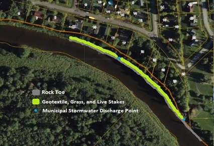
Fort Folly Habitat Recovery, in partnership with the Village of Salisbury and 5R Environmental Consulting Inc., completed a bank stabilization project in Highland Park at the head-of-tide along the main stem of the Petitcodiac River (Home page: first photo). In addition to Highland Park, the failing bank slope upon which this work took place was mostly Crown Land immediately upstream of the park, sandwiched between the river and private residences (Figure 28 and Figure 29).
The bank at that location lies along the outside curve of the river and is subject to significant erosive force from stormflow and ice during the winter and spring freshet. Some years ago, installation of a hardened municipal stormwater discharge point midway along the bank altered the radius of curvature of the river and promoted eddies and currents against the bank, which produced slumpage and failure of the bank immediately upstream and downstream of it.
The restoration design was focused on re-establishing the natural radius of curvature through this reach of the river while maintaining a channel width that going forward will allow freshet flows and significant stormflow events to pass
without creating substantial erosional damage. It did so by constructing an approximately 450 m long rock toe along the base of the bank in 2020, and then reconstructing a 300 m length of the bank slope above that in 2021, at which point the site was seeded and planted with live stakes of willow and dogwood.

An additional challenge facing this site is ongoing changes in the river as a consequence of the Province of New Brunswick’s Petitcodiac River Restoration Project. In April 2021 the new 160-metre-wide channel was opened beneath the recently completed Robertson Bridge linking Moncton and Riverview, 22 kilometers downstream. This bridge replaced the 50-metre channel provided by the gates of the Petitcodiac Causeway control structure. Notably stronger tides began to arrive at Highland Park in late May 2021 just a few weeks later. The following year, on May 17th, 2022, the site experienced a 2.95 m amplitude tide (on the gauge at the Salisbury Railway Bridge more than 2 km downstream), at the time by far the strongest recorded since the causeway gates opened in 2010 (when the maximum had been only 1.8 m amplitude).
That record then fell in 2023 when there were no fewer than 5 tides between May and October which exceeded 3.1 metres on the gauge at the railway bridge. The 1.8 m record tide in 2010 would not even have reached as far upstream as this portion of the bank, whereas the biggest of these 2022 and 2023 tides, being 1.1 to 1.3 m in amplitude beyond that 2010 tide, inundated this section of bank to a depth of 20 to 30 cm, bringing salt, silt, and debris from the estuary along with them. The log in the 2022 photo in Figure 29 was left after being brought upstream by the tide rather than downstream by stormflow as one might have otherwise assumed. Not only will tides such as these continue into the future, but as conditions evolve, tides are likely to become expressed with even more strength over time.
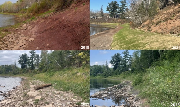
The 2018 photos in Figures 28 and 29 were taken prior to work beginning at the site, while still developing a restoration design and pursuing funding for the project. One can see quite a bit of a difference, as there was more woody vegetation then, which subsequently fell away as the bank was undermined and collapsed prior to work at the site beginning in 2020. The 2021 photos were taken in November of that year after work on the bank had been completed, and the 2022 photos are from September, late in the growing season. Meanwhile the 2023 photos were taken in August.
The late timing of the photos in 2022 was intentional, to capture the full growth and development at the site. A winter storm on February 18th, 2022, had inflicted significant damage on this site before the vegetation planted in the fall of 2021 had sufficient opportunity to become well established. A couple of days of unseasonably warm temperatures (high 11.7 °C) in mid-February 2022, along with 15 mm of rain produced a rapid melt of the accumulated snowpack (from 84 cm on February 16th down to 18 cm on February 19th). With the ground still frozen, combined water from the rain and melted snow flowed into the river, breaking up the ice and generating flooding that according to the river gauge in Salisbury a short distance downstream peaked more than 3 metres above the level the river had been at prior to this event. That storm was an extreme event which produced the highest discharge recorded by the gauge upstream in the Village of Petitcodiac since 1970 (the Salisbury gauge only goes back to 2010). Scouring ice carried by this event did considerable damage to the reconstructed bank. Additional work in the spring of 2022 was required to further rehabilitate the bank, meaning that development of the vegetation was delayed compared to if the site had survived the winter undisturbed.
Vegetation was planted at the site in 2021 as per Figure 30. A mixture of 1,880 willow and 590 dogwood live stakes were distributed evenly across the bank by collecting and planting them in the fall of 2021. Initial density across the approximately 600 m2 of revegetated bank averaged about 4.1 stems per m2. The purpose of such an initially high density was to a) allow some degree of cushion for anticipated mortality, and b) comply with the requirements of the WAWA permit for the project which understandably makes such an initial built in cushion in stocking levels mandatory. Long-term, as the vegetation becomes established, sustaining a target of 1 stem per m2 is likely to be sufficient.
As noted previously, the winter storm in February 2022 took quite a toll on the site. . In May 2022 as part of making repairs an additional 674 willow and 65 dogwood were planted along the bank to replace losses from the storm. Vegetation planted in fall 2021 and spring 2022, as well as the results of the survey of established vegetation in the summers of 2022 and 2023 are presented in Table 6. By 2023 there was a stocking rate of 1.06 stems per m2, with natural recruitment accounting for 9% of the total, and species diversity having jumped from 4 species in 2022 to 12 species in 2023.
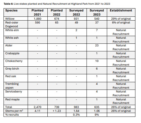
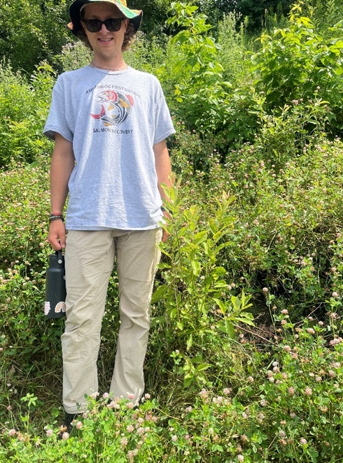
Figure 31 shows a willow live stake on the bank in July 2023. It is now well established, likely about twice the size it would have been a year previously. Such vigorous growth indicates production of roots that together with the grass and clover growing around it should bind the soil to help provide long term structural stability on reconstructed bank slope.
The repeat photography time series of photos in Figure 28 and Figure 29, and the vegetation monitoring are part of the long-term monitoring the FFHR conducts at its sites, following restoration. Since 2022, once the vegetation had an opportunity to become well established, slope stability has remained high. This observation was documented and quantified by surveying a series of cross sections across the length of the site. The initial 2021 post construction survey was made irrelevant by the winter (2021-22) storm. Consequently going forward the post repair survey in 2022 was used as a new baseline, to which the 2023 survey was compared.
In addition to vegetation, repeat photography, and cross sectionals surveys, other long-term monitoring ongoing at the site compared to 2020 pre-construction baselines includes electrofishing to assess how fish are responding to the work done, and Canadian Aquatic Biomonitoring Network (CABIN) wadeable streams monitoring (Environment Canada 2011). The latter examines aquatic insect populations – particularly Ephemeroptera (Mayflies), Plecoptera (Stoneflies), and Trichoptera (Caddisflies)- EPT species- as these are typically the most sensitive to habitat disturbance. Even distribution and high numbers serve as good indicators of water quality. As residents of the site the state of such populations can provide longer term insights into conditions there than conventional water sampling which provides only an ephemeral snapshot in time.


