Third Level Assessment – Aquatic and Riparian Habitat Assessment
Head-of-Tide
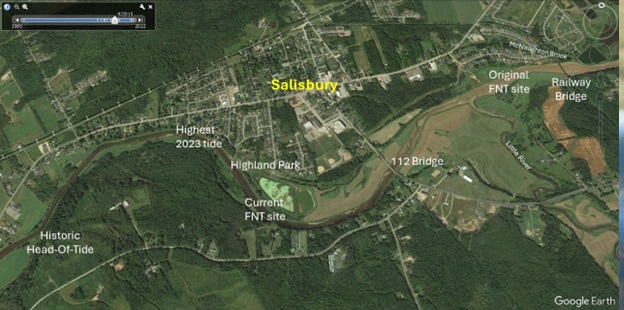
The lowest 4 km of the main stem lies within the historical head-of-tide on the Petitcodiac. The Bannister Brook Composite, the lower of the two regions that make up the main stem, ends at the mouth of Little River on the right bank, and the mouth of McNaughton Brook on the left bank, just below the railway bridge in Salisbury. The silt flats beneath the railway bridge in Figure 4 have developed during the 14 years since causeway gates were opened. Figure 17 is based on imagery from September of 2015, which shows the silt brought upstream by the tide ending at approximately the Route 112 bridge over the Petitcodiac in Salisbury. There is a notable difference in the colour of the river above that point and below that point. Tides have continued to increase in amplitude since that time such that the channel above the Route 112 bridge in Salisbury which had constantly had a gravel bottom is accumulating silt flats (Figure 18). The furthest extent of tide in 2023 shown in Figure 17 was just beyond Highland Park. That comes close to, but still falls roughly 1 km short of the historic head of tide. Despite the new channel under the Honorable Brenda Robertson Bridge being roughly 160 m wide, tides are unlikely to achieve the historic amplitude, as the pre-causeway channel tides passed through was much larger- approximately 1 km wide.

The Petitcodiac estuary naturally has a high suspended sediment load, typically around 30,000 milligrams per litre (mg/L) (AMEC 2005). To better grasp this, 30,000 mg is 30 grams (i.e., slightly more than 1 ounce) of sediment per litre of water, the colour of which gives the river its nickname – the Chocolate River. The primary source of this sediment is coastal erosion in the Bay of Fundy (Plint 1986; Schell 1998; Haralampides and Rodriguez 2006).
The banks and tidal flats along the estuary have accumulated a large store of this silt and clay and it is easily suspended and redistributed (Bray et al. 1982). Prior to construction of the causeway, the amount of water (tidal prism) flowing into the river from the ocean twice a day on the tide was around 450 cubic kilometres (km3), which fell to about 200 km3 when the upper part of the estuary was cut off by the causeway and the downstream channel had filled with silt (Morris and Mitchell 2013). The original tidal prism scoured a massive drainage channel 1 km wide at the causeway site making the river appear larger than it would be based upon its freshwater discharge alone. Elimination of the portion of the tidal prism from above the causeway reduced the volume of water flowing out of the estuary on ebb tides (Schweiger 1986), and resulted in massive sedimentation, as the system shifted towards a new equilibrium (ADI 1979; Bray et al. 1982). Sediment cores extracted near the causeway show layers of silt 3 mm thick, which were deposited on each tide, accumulating to a depth of 7 m over the three-year causeway construction (Haralampides and Rodriguez 2006). This eventually narrowed the channel below the causeway by 92% from 1 km down to 80 m (Harvey 1997), with the effects of this infilling extending 21 km downstream of the causeway (Van Proosdij et al. 2009). As the channel silted in, the bottom elevation of the wetted channel increased as well. The tidal bore, which had ranged from 1 to 1.5 m in height, declined to a small fraction of a metre in the portions of the estuary still subject to tidal influence (Morand and Haralampides 2006).
Tidal bores are a phenomenon created as incoming tides are funneled into a shallow, narrowing river or lake from a broad bay (Chanson 2009). It is a wavefront of water “boring” its way upstream against the natural flow of the river, followed by the rising tide (Dalton 1951). Near the new bridge in Moncton, the arrival of the bore immediately increases the depth of the river by nearly 1 m. Once the bore passes, the tide continues to rise for more than 2 hours, increasing the depth of the river at that site by about 10 m (Lynch 1982). It takes approximately 2.5 hours to go from low water to high water in Moncton, but the tide ebbs gradually, requiring about 9 hours to drop from high to low. The tidal amplitude is much lower at the FNT site upstream at the head-of-tide. Due to the lower amplitude, less time is required to drain back to baseflow at the trap site, but the basic asymmetry between the rising and falling limbs of the tide remains.
Arriving as a wave of focused energy and water funneled upstream by the river channel, such asymmetric tides are not just a consequence of the volume of water, they are also shaped by the energy behind it (Lynch 1982). The bore is like a wave crashing and retreating on a shore; it moves so gradually for such a distance that the tide is rising upriver at Salisbury even as the water level at the Petitcodiac’s mouth begins to recede as the tide drains out into the Bay. Friction against the river bottom drains energy from the bore and, if the speed of the bore becomes less than that of the river, it will be swept back downstream.
Prior to construction of the causeway, Elson (1961) described the upper part of the Petitcodiac estuary near Salisbury as a challenging environment that functions as a “rather violent transport area” between freshwater and the more stable sea environment. He noted that the tidal bore was disruptive of fish orientation in the river due to turbidity and turbulence, and that small smolt sized fish were ”tossed” by the wave of the bore and preyed upon by gulls during its passage.
The strength of the tides making their way up to this portion of the river increased rapidly once the gates were opened in 2010. This effect accelerated in 2021 after the new 160 m wide channel opened under the bridge. As early as 2012, silt had shifted such that approximately 1 km downstream of the causeway’s control structure, the river channel had widened by as much as 20 m and at 10 km downstream it was about 350 m wider than before the gate opening (AMEC 2013).
The widening channel has provided a more efficient conduit and allowed the bore to express itself more strongly. This has likely contributed to the observed growth in the size of tides arriving at the head-of-tide over the years. The maximum tide recorded at the railway bridge in Salisbury has increased markedly from 1.8 m above the baseflow of the river in 2010 to 3.1 m (on five separate occasions) during 2023 (Gemtec 2023). Average tides detected on the Salisbury gauge in 2023 increased even more notably – up 1.19 m compared to 2010, and 0.57 m compared to 2022 (Redfield 2024).


