Fourth Level Assessment – Aquatic Habitat Rehabilitation Plan
Culvert Remediation
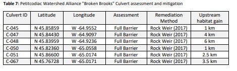
Work to remediate culverts identified as barriers to fish passage has been undertaken within the Little River by the Petitcodiac Watershed Alliance as part of their Broken Brooks project between 2014 and 2022. Culvert C-051 located where Route 895 intersects Mitton Brook was found to be a full barrier to fish passage during the 2014 culvert survey. It was identified as a candidate for construction of a rock weir below the outflow and provides an example of the technique. Installing this rock weir allowed fish access to approximately 2.5 km in length and 6.03 km² of upstream habitat. The PWA has identified and remediated 6 culverts in this manner within the watershed (Figure 17 and Table 7).
Culverts that are not properly designed can create a drop, or change in elevation, between the culvert outflow and the stream flowing through it. Culvert C-051 has a downstream slope of 3.79% and an outflow drop of 19 cm, potentially blocking approximately 2.5 km of upstream habitat for brook trout and other species. Large changes in elevations between the outflow drop and stream can prevent fish from jumping into the culvert and migrating upstream. The PWA follows the guidelines for remediation options listed in Table 8.

To reduce this barrier, a vortex rock weir design was selected. By installing this type of structure water levels are raised in the plunge pool and the barrier outflow drop is effectively eliminated. The size and volume of the rock weir is based upon the stream and culvert characteristics and can be calculated using data collected from the culvert assessment.
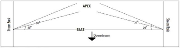
The apex or low flow notch (located at the center of the weir where water can flow during times of lower volume) has the lowest point of elevation and points upstream. The wings of the weirs were built at a 30° angle from the base of the weir (Figure 30). Gradual reduction of the outflow drop was visible during rock weir construction. Comparison of before and after outflow drop photos below show that the outflow drop was successfully reduced (Figure 31). Over time, the watercourse will naturally deposit material within the rock weir and fortify the structure. Stream-crossing structures should be inspected and maintained on a regular basis, especially following high water flow season and large rainfall events.