Second Level Assessment- Current Impacts
Transportation Development
Transportation Development
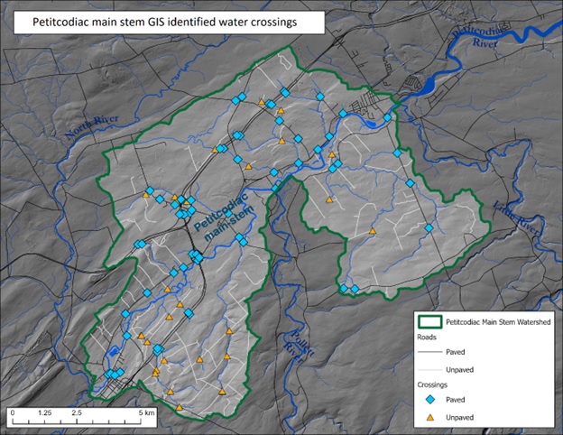
A GIS layer of the road network (paved and unpaved) within the main stem of the Petitcodiac was overlaid on the river and its tributaries, to yield Figure 7. This analysis indicated a total of 95 locations where roads crossed the river or tributary streams. Of this 66 were defined as paved, and 29 were defined as unpaved. Being 69% paved high ratio of compared to the experience elsewhere in the Petitcodiac system, as typically there are numerous water crossings by unpaved roads. That said, the main stem of the Petitcodiac is more populated and developed than the various tributaries, and so a higher proportion of paved roads was to be expected. For comparison’s sake, comparable figures for other watersheds for which FFHR has developed stewardship plans ranked according to proportion of paved crossings are as follows: North River 58% paved; Little River 54% paved, Anagance River 42% paved; Demoiselle River 40% paved; and Pollett River 31% paved. The number of crossings appears not unreasonable for the small area involved (115.2 square kilometers). For comparison’s sake the total number of crossings within the 264.8 square kilometers of the North River watershed is 155, of which there are 90 paved and 65 unpaved. Though a much larger area of watershed, the North is comparable in many ways in terms of the extent of development within the main stem.
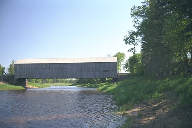
A thorough inventory of the condition of all of these crossings is needed to examine the extent to which these may be limiting fish passage. Systematic collection of such data will also provide an opportunity to test the GIS analysis, and determine how many crossings that it has missed, and where they are. While several crossings within the main stem composite basins are known to be bridges such as the Rt 112 bridge in Salisbury, or the Powers Pit Rd Covered Bridge (Figure 8), the majority are likely to be culverts of varying size and condition.
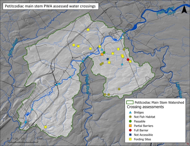
The Petitcodiac Watershed Alliance has carried out a series of culvert surveys throughout the Petitcodiac watershed as part of their Broken Brooks project. Annual reports detailing that work are available for download on the publications section of their website https://www.petitcodiacwatershed.org/ . These reports indicate 37 crossings assessed within the main stem area to date: 12 bridges, 12 fording sites, 3 culverts that were full barriers to fish passage, 3 culverts that were partial barriers to fish passage, 7 culverts that were not fish habitat, and 1 culvert that was not accessible (Petitcodiac Watershed Alliance 2017). Comparison of the crossings that they have assessed to the 95 identified through this GIS analysis indicates that at least 58 water crossings within the main stem of the Petitcodiac remain to be assessed.
Several of crossings that they examined were identified as problem culverts creating barriers to fish passage into useful habitat, potentially benefiting from remediation such as clearing of brush blockages or construction of rock weirs raise water levels in the case of perched culverts (Petitcodiac Watershed Alliance 2016). At least one culvert, on Duncan Brook within the Bannister Brook Composite (N 45.99879 W-65.0234), was noted as a good candidate for replacement (Petitcodiac Watershed Alliance 2017).
While the New Brunswick Department of Transportation (DoT) is responsible for bridges and culverts on the public paved roads, they are not responsible for the vast majority of culverts on unpaved roads which are likely to be on either private woodlots, industrial freehold, or crown land. If a problem culvert is identified and there is a question of who is responsible (private landowner versus DoT), using GPS coordinates responsibility will be confirmed through further discussions with the Department of Transportation.
In 1968, 22 kilometers downstream of the head of tide, in the Petitcodiac estuary, the Petitcodiac Causeway was built instead of a bridge, in order to accommodate vehicular traffic between Moncton and Riverview. The fishway built into it proved to be ineffective. The causeway gates created a barrier to fish passage with significant consequences for native fish species in the river and led to the decline in the populations of species such as alewife, blueback herring, rainbow smelt, and sea-run brook trout. Some species disappeared altogether from the upland reaches of the Petitcodiac (such as the Little), including Atlantic tomcod, American shad, and striped bass (Locke, et al. 2003). Atlantic salmon only remained present in the river as a consequence of ongoing stocking efforts (AMEC 2005)
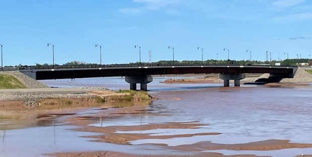
In April 2010 the gates of the causeway control structure were opened as part of the Petitcodiac River restoration project. On May 25th, 2021, the new channel was opened underneath the bridge built to partially replace the Petitcodiac Causeway (Figure 10). October 5th, 2023, this bridge was named in honor of the late senator and MLA Brenda Robertson (Government of New Brunswick 2023a). Fourteen years of monitoring from 2010 to 2023 following the restoration of fish passage (Redfield 2024) found American shad, striped bass, and Atlantic tomcod returning to the river. Of these, the latter two have shown sustained and progressive increases in numbers over the years, while invasive non-native smallmouth bass have declined. Consequently, it is clear from these results that the fish community of the Petitcodiac has the capacity to recover, given the right conditions, and appears to be on its way to doing so.