Third Level Assessment – Aquatic and Riparian Habitat Assessment
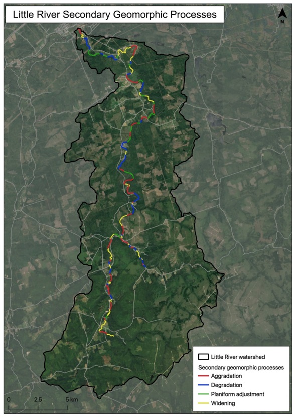
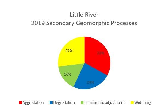
Secondary Geomorphic Processes
Secondary Geomorphic Processes (Figure 15 and Figure 16) are a bit more evenly distributed amongst the various types. Aggradation (33%) and widening (27%) still dominate as the most common two secondary processes occurring, however degradation (24%) and planform adjustment (16%) more prevalent here than these were among the primary processes. Combined, widening is either the primary or secondary geomorphic process along 73% of the assessed length of the Little River, while aggradation is either the primary or secondary geomorphic process along 65% of the river.
With 55% of the assessed length of the Little River ranked as “in adjustment” and only 2% is stable i.e. “in regime”, while the remaining 43% lies somewhere in between ranked as “transitional or stressed”, it is clear that the Little River is experiencing significant levels of disturbance. Much of this is likely due to the combined impacts of land use practices (both agriculture and forestry), increasing sediment load to the system, an increase in runoff during rain or freshet events, possibly even adjustment to the channel depth and width due to impacts from climate change.
Reaches with aggradation factor score of greater than 0.5 should be considered priority reaches for instream habitat or channel restoration activities. However, as mentioned, identifying the source of the aggradation would be the first priority so any works completed instream would not be buried by excess sediment or bedload material. Once the source of channel aggradation has been identified, any instream restoration techniques or designs would need to consider the management of the excess channel material so that it is dispersed or relocated in areas that are natural depositional locations. The installation of bank restoration techniques or instream structures will also need to be designed around attaining the channel back to a more natural width. The correct channel width should be calculated for each reach to ensure that the channel width is able to accommodate the flows based on the hydraulic flow conditions of that reach.


