Third Level Assessment – Aquatic and Riparian Habitat Assessment
Water Quality
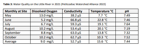
The PWA has been monitoring water quality within the Petitcodiac Watershed with the help of government organisations and volunteers since 1997, and has been collecting its own monthly water quality data since 1999 (Petitcodiac Watershed Alliance 2022). That being the case their data set has decades of time depth available for comparisons. PWA collects from a single fixed monitoring site, near the mouth of the Little River, the logic being to provide an indication of conditions for the entire watershed upstream of that point. Greater resolution would be challenging, as PWA also conducts similar monitoring for numerous other tributaries distributed across the Petitcodiac and Memramcook watersheds. The location on the Little River monitoring site is below the Rt 112 Bridge (the first bridge on the Little, roughly 1km above its confluence with the main stem of the Petitcodiac. Data is collected monthly from May to October, measuring a range of parameters including those focused on below in Table 3: Dissolved Oxygen, Conductivity, pH, and Temperature.