Fourth Level Assessment – Aquatic Habitat Rehabilitation Plan
Bank Restoration
Little River below the first 895 Bridge 2017 (Fort Folly Habitat recovery)
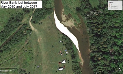
The cause of the instability at this site appears to be water (and energy) deflected off the footings of the first Rt 895 bridge over the Little River, approximately 200 metres upstream. Little can be done to change the bridge, however the bank after this work is now better able to withstand forces directed against it. Figure 20 illustrates based on historical imagery how during the 7 years between 2010 and 2017 an area of 1,235 m2 of bank was lost. This area is marked in white- the right side indicating the bank in 2010, and the left the bank in 2017. An average of 176 m2 were lost per year as the river widened and shallowed to produce the gravel bars filling what had been the old channel, as the main flow shifted into the now missing bank area. Assuming approximately 1 m3 of soil per m2 of bank lost suggests something like an average of 176 m3 of sediment per year every year were entering the river at that site.
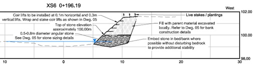
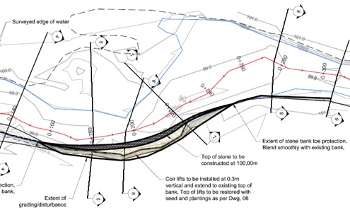
This section of bank lies a short distance upstream of a site (Figure 8) where redd surveys for iBoF Atlantic salmon have regularly detected use of spawning gravel to build redds in which to deposit eggs during spawning. The large volumes of silt coming off this site posed a risk of smothering such redds, suffocating the eggs within them. It is also worth noting that not only is this site itself home to brook floaters which are vulnerable to sediment, but the massive brook floater bed downstream that Hanson (Personal Communication 2018) noted was suffocated by eutrophication in 2013 (Figure 9) lies only about 4 km below this site. This is not to suggest that the soil coming off this site was uniquely the cause of the eutrophication event that wiped out that mussel bed, however given the volume of soil being lost and the time that both were happening, soil from this bank almost certainly would have contributed to that result. Figure 21 provides a cross-section of the reconstructed bank while Figure 22 shows the lay out of the site with the rock toe running the length and bank lifts stepped back above it.

Vegetation was planted as per Figure 23. Initial density across the entire 750 m2 of revegetated bank averaged approximately 0.95 stems per m2. The site was damaged somewhat by a storm in 2018 during the first winter after it had been restored, prior to the point where the vegetation had had much opportunity to establish roots. Follow up work at the site in the spring of 2018 addressed these issues, reseeding and replanting as needed. Vegetation survey in 2022 found that density had increased to 1.19 stems per m2 as a result of natural recruitment, with 5 additional species present on site (Table 6)
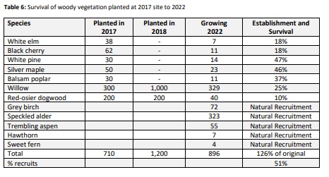
The recruitment of sweet fern (Comptonia peregrina) to the site is of particular interest (Figure 24). Contrary to the name this is not a fern, but a woody shrub with fern-like leaves. The species itself is not rare per se, ranked S5 (Secure) meaning it is common, widespread, and abundant in New Brunswick (ACCDC 2023). However sweet fern has a fairly spotty distribution within the Petitcodiac watershed, and this is the first time FFHR had noted it on Little River, though it has been seen previously here and there on the Pollett and along the main-stem of the Petitcodiac. Presumably sweet fern is present somewhere upstream on the Little River and the seed simply washed in and was deposited on the site during one or more flood events over the last several years. Other species showing up on the site due to natural recruitment are less remarkable. These were likely present among the vegetation on site before the bank was reconstructed. The alder and the aspen probably developed from root fragments that persisted in the soil. Meanwhile hawthorn and grey birch may have grown from a combination of seed produced by vegetation immediately adjacent to the site, from seed lying dormant in the soil, or like the sweet fern, from seed transported some distance and deposited on the site during a flood event.

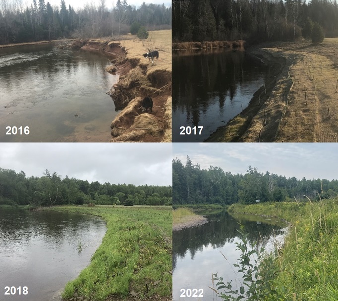
Figure 25 shows a repeat photography time series of photos of the site taken from upstream looking downstream, from 2016 (before work was done there) until 2022. Since 2018, in addition to the vegetation becoming well established, slope stability has remained high. This observation was documented and quantified by surveying a series of cross sections across the length of the site, post construction in 2017, and subsequently repeating the survey in 2022 to allow comparison. Other long term monitoring ongoing at the site compared to 2017 pre-construction baselines includes electrofishing to assess how fish are responding to the work done, and Canadian Aquatic Biomonitoring Network (CABIN) wadeable streams monitoring (Environment Canada 2011). The latter examines aquatic insect populations – particularly Ephemeroptera (Mayflies), Plecoptera (Stoneflies), and Trichoptera (Caddisflies)- EPT species- as these are typically the most sensitive to habitat disturbance. Even distribution and high numbers serve as good indicators of water quality. As residents of the site the state of such populations can provide longer term insights into conditions there than conventional water sampling which provides only a snapshot in time.