Fourth Level Assessment- Aquatic Habitat Rehabilitation Plan
Pollett, first pool 2019 (Fort Folly Habitat Recovery)
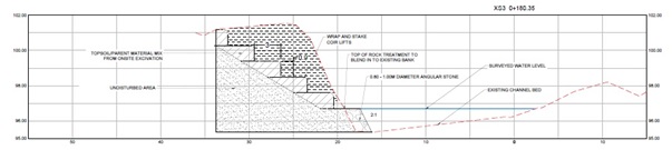
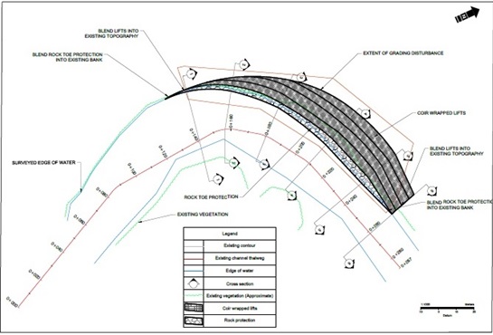
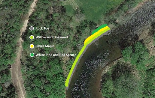
A second bank stabilization project was undertaken on the Pollett in 2019, this one by Fort Folly Habitat Recovery, at a location (cover, top photo) a little over 500 metres further upstream from the portion of the riverbank that the PWA worked on in 2014. The base of the bank was stabilized with a rock toe and the slope was reconstructed to produce a more stable angle of repose Figure 21 and Figure 22. The site was then seeded with grass, and the lower portion planted with live stakes of willow and dogwood while top of the mid-slope of the bank was planted with silver maple, and the top with white pine, and red spruce seedlings (Figure 23).
Initial density across the entire 350 square metres of revegetated bank averaged approximately 1.7 stems per square metre. Some live stakes failed to become established while others grew but have since been lost to competition with grasses. Tree seedlings higher on the bank experienced similar challenges however, their numbers were augmented by supplementary planting. Table 6 lists the woody vegetation on site in 2022.

The impressive recruitment of 130 red oak seedlings to the site (32% of total stocking) was largely a consequence of a fortuitously timed heavy crop of acorns landing on bare mineral soil just as the site was being reconstructed in 2019 (Figure 24). Oaks are naturally abundant on the site, and as a result there had been an intention to include oaks among the seedlings being planted since they clearly do well there. However, once trees present on the site naturally seeded it themselves, doing so was deemed redundant, especially since promotion of the native population of oaks on the site would be preferable. Three years later, in 2022 the resulting seedlings are thriving (Figure 25).

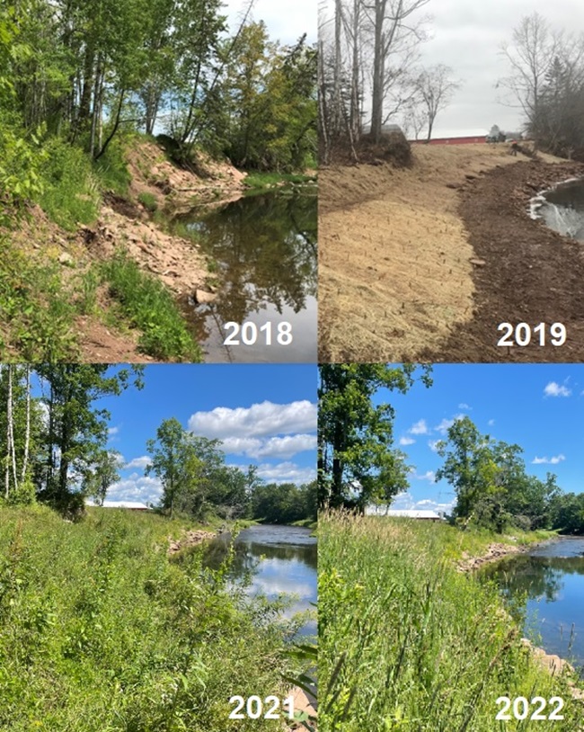
Figure 26 shows a repeat photography time series of photos of the site taken from upstream looking downstream, from 2018 (before work was done there) until 2022. Since 2019, in addition to the vegetation becoming well established, slope stability has remained high. This observation was documented and quantified by surveying a series of cross sections across the length of the site, post construction in 2019, and subsequently repeating the survey in 2022 to allow comparison. Other long-term monitoring ongoing at the site compared to 2019 pre-construction baselines includes electrofishing to assess how fish are responding to the work done, and Canadian Aquatic Biomonitoring Network (CABIN) wadeable streams monitoring (CABIN 2012). The latter examines aquatic insect populations – particularly Ephemeroptera (Mayflies), Plecoptera (Stoneflies), and Trichoptera (Caddisflies)- EPT species- as these are typically the most sensitive to habitat disturbance. Even distribution and high numbers serve as good indicators of water quality. As residents of the site the state of such populations can provide longer term insights into conditions there than conventional water sampling which provides only a snapshot in time.
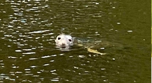
Several other significant observations make this site noteworthy, despite not being directly related to monitoring of the restoration work done there. These include the occasional adult salmon observed holding in the pool there. These are likely present due to salmon recovery efforts within the system- both releases by Fundy Salmon Recovery, and DFO’s Live Gene Bank. Likewise, numerous large 40 cm to 60 cm striped bass (Figure 27) have been consistently detected in the same pool in August during four of the last five years (2018, 2019, 2020, and 2022). The only exception was in 2021. No striped bass were observed there August 2021, perhaps because several weeks earlier in July a seal (Figure 28) was seen in it by the PWA while they were there to collect their monthly water sample (this is also the station where the water quality samples reported in Table 3 are collected). It seems possible that this seal either dispersed or consumed any striped bass that had been in the pool that year. The salmon, the striped bass, and the seal are all only present here on the Pollett because of improved passage downstream due to the Province of New Brunswick’s Petitcodiac River Restoration Project opening the causeway gates in 2010, and then the wider channel under the new bridge in 2021.